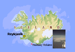
The click-able map of Iceland was produced to have a better overview
over the locations of the images shown. There is a kind of a
zoom-mechanism which is not fully developed and needs some
clarification here.
A click with the pointer exactly over an icon leads to the
according image page which was created using the
pcd2html
systems on
two Photo CDs. These pages
contain comments to the images and links to other images in this region.
Clicking into the near environment of an icon leads to a zoomed
section of the map with more images or the index page of the selected
area from the Photo CD images.
Icons in the border zone of the maps often lead to neighbor areas of the
section. If there is an area on the map I did not visited the link
could turn back to the next higher zoom level. Unfortunately a
"back"-link to the higher level is not implemented, yet.
The click-able maps were created exclusively using
Paul
To gain a higher flexibility (for possibly later images) I build a
kind of a database of the coordinates of the icons. The resulting
maps and HTML pages were calculated by a perl-script. I plan to
include these script as an example into higher paul versions.
| Deutsche Version dieser Seite |